Fire damage to U.S. buildings projected to nearly triple by mid-century under a no-adaptation scenario
A projection through 2060 finds structural losses from fire nearly tripling without adaptation. The West remains the most affected region, while risk expands eastward.
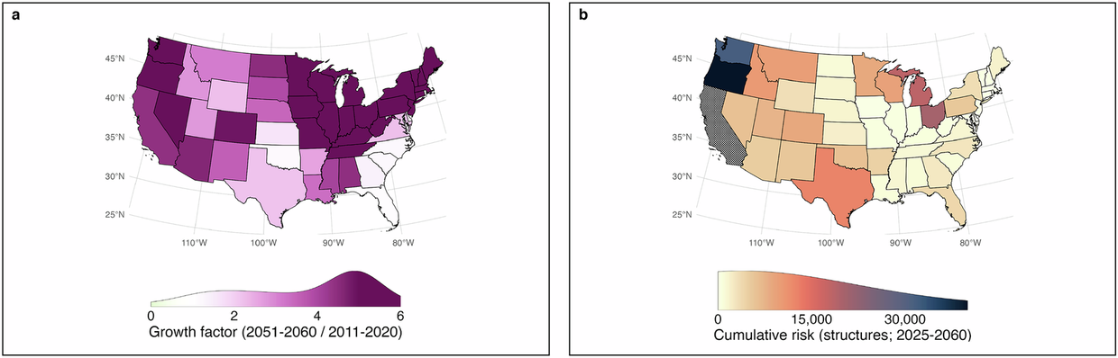
Researchers reconstructed fire risk to structures across the contiguous United States for 1945–2023 and projected its evolution through 2060. The results were published in Nature Communications. Under business-as-usual conditions with no adaptation, structural losses are projected to nearly triple nationwide. By mid-century, 133,200–449,100 buildings are expected to be damaged or destroyed doi.org
Nature Communicationsdoi.orgOpen source ↗. The authors stress that the results are plausible scenarios rather than precise forecasts.
Method and data
The authors define fire risk, following the Intergovernmental Panel on Climate Change, as the expected annual structural loss. It arises from the interaction of hazard, exposure and vulnerability doi.org
Nature Communicationsdoi.orgOpen source ↗. Hazard is represented by observed and projected burned area, exposure by the distribution and number of structures, and vulnerability by the Exposure-Adjusted Structural Loss Index (EASLI), derived from historical observations.
The fire hazard was modeled with a spatiotemporal wildfire model that uses a 30-year wildfire record together with meteorological, climatic and housing-density data. It was driven by three General Circulation Models under a moderate-mitigation emissions scenario doi.org
Nature Communicationsdoi.orgOpen source ↗. According to the authors, many existing assessments treat exposure as static and describe settlement patterns only coarsely. Here, fire and development are projected jointly.
Where losses concentrate
Between 1985 and 2023, nearly 589 million hectares burned across the country, 85% of it in the West doi.org
Nature Communicationsdoi.orgOpen source ↗. The West remains the epicenter of projected losses. There, 30% of the census tracts projected to face the highest fire risk intersect with socioeconomic hardship, so the greatest losses may fall on some of the most vulnerable communities
doi.org
Nature Communicationsdoi.orgOpen source ↗.
Among states, California has the largest projected cumulative loss: 156,500 structures destroyed from 2025 to 2060, according to the model mean doi.org
Nature Communicationsdoi.orgOpen source ↗. The authors also report an eastward expansion of risk that is already underway. They note that since the mid-1970s housing expansion into fire-prone regions has accelerated, with a tenfold increase in built-up land in fire hotspots
doi.org
Nature Communicationsdoi.orgOpen source ↗.