Permafrost slopes in Canada's Mackenzie Valley detached from a thawing base, moving 4.5 and 18 million m³
Geologists describe a new landslide type, the permafrost detachment slide, in which the whole frozen layer fails from the bottom up. Hundreds of similar landslides were identified in the region.
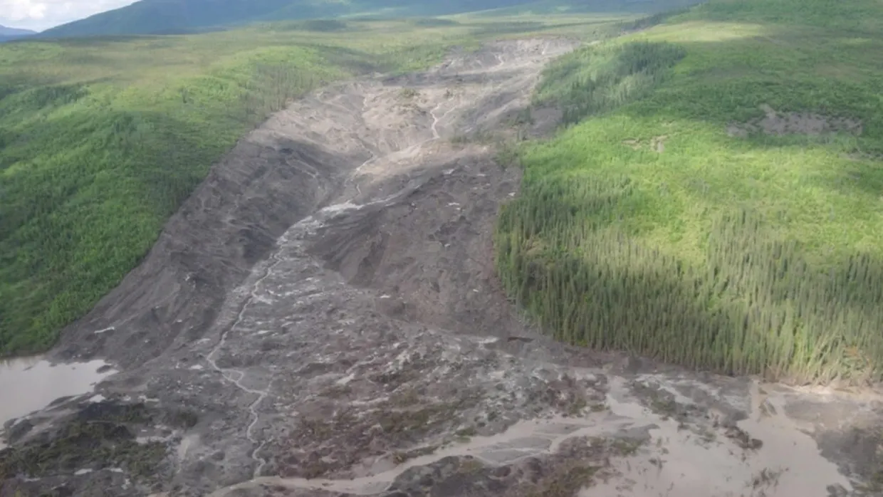
A team including geologist Joseph Young of the University of Alberta has described two large landslides in the central Mackenzie Valley, Northwest Territories, Canada. The study was published in Geophysical Research Letters. The failures occurred in 2017 and 2018, near the Redstone and Johnson rivers, and moved about 4.5 and 18 million cubic meters of frozen material into downstream environments agu.org
Geophysical Research Lettersagu.orgOpen source ↗. The authors call this type of failure a permafrost detachment slide.
Failure from the base of the permafrost
These slopes did not thaw at the surface and slump, as is usual in permafrost terrain. According to the authors, the mechanism is bottom-up thaw, which starts a gradual movement of the entire permafrost layer and produces distinct failure styles and deposits. The failure surface lay about 18 to 20 meters deep, and the frozen layer moved downhill in blocks, many still carrying vegetation.
Initial movement opens extensional cracks. They let more water infiltrate, which accelerates thaw at depth and leads to slope failure. At Johnson River, Landsat images showed the slope creeping 10 to 30 meters a year for more than a decade before it failed, and the movement sped up until the collapse. The debris blocked drainage below both slides, and lakes about 1.1 and 3.5 kilometers long formed behind it.
Thin, warm permafrost and fire
The authors identified hundreds of similar landslides in the Mackenzie Valley, where permafrost is relatively thin (under 40 meters) and warm (above −1°C) agu.org
Geophysical Research Lettersagu.orgOpen source ↗. Thermal modeling indicates that fire-induced effects can cause thawing at the permafrost base over decadal timescales. In the FreeThaw1D simulation, a fire was a 1.5°C rise in surface temperature that faded over 75 years, and ice near the base, about 20 meters down, began to thin only decades later. Both study areas burned in 1995. In an earlier paper the same group counted 156 deep-seated permafrost landslides in the valley that began between 2004 and 2020.
The model leaves out background climate warming, local site conditions and water draining through tension cracks. The authors say that water is likely a stronger driver of deep thaw than slow heat conduction through the soil. Only two slides were studied on the ground, and the hundreds of mapped landslides have not been checked one by one.
The effects persist after the rapid failure. Thermokarst processes alter the ice-rich scarps and deposits, mobilizing sediments, solutes and carbon into downstream environments.