Greenland fjord landslide set off a 92-second seismic signal for nine days, SWOT satellite data show
A rockslide into a Greenland fjord set off a standing wave that rang Earth's crust every 92 seconds; SWOT radar mapped the water motion from orbit.
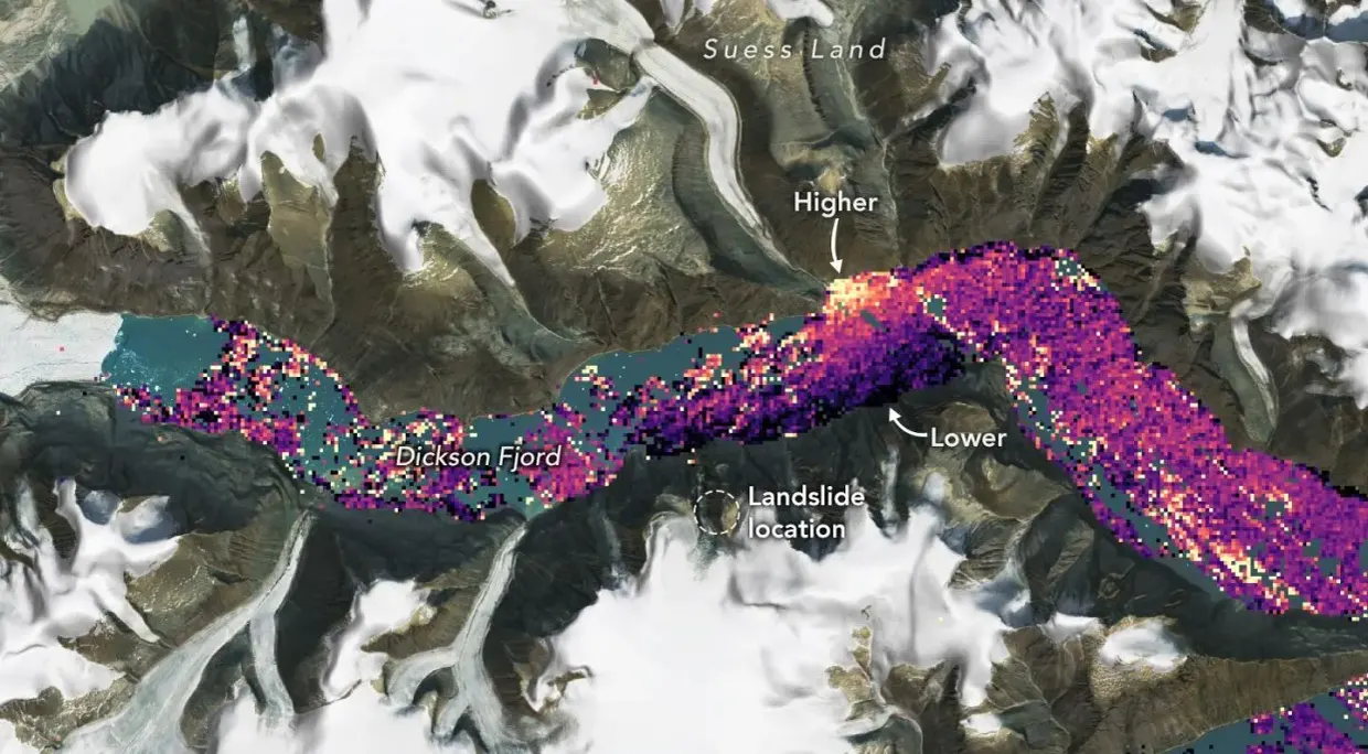
Instruments thousands of miles apart registered a low-frequency seismic signal with a steady 92-second interval for up to nine days after a mountainside collapsed into Dickson Fjord in East Greenland on September 16, 2023, according to futura-sciences.com futura-sciences.com
futura-sciences.comfutura-sciences.comOpen source ↗. The cause was traced to water trapped in the fjord, and in 2025 satellite radar confirmed it directly.
The collapse and the trapped wave
An estimated 25 million cubic meters of rock fell and picked up glacier ice on the way down. It entered the water as a mixed avalanche and drove water more than 200 meters (650 feet) up the adjacent slopes. Lead author Kristian Svennevig, writing in Science, documented an average runup of 60 meters along 10 kilometers of the fjord. A second, smaller landslide struck the same site on October 11.
Angela Carrillo-Ponce showed in The Seismic Record that a sharp bend near the fjord outlet blocked the wave. Unable to escape into the open sea, the surge turned into a standing wave, a seiche. The water rocked across the channel, and each impact against the rock walls sent low-frequency seismic waves through the planet at the same 92-second interval.
Radar from orbit
Researchers first inferred the wave mechanics from land-based sensors. Direct evidence came later: in Nature Communications (June 3, 2025), Thomas Monahan and colleagues used data from the SWOT satellite to build two-dimensional maps of the fjord surface futura-sciences.com
futura-sciences.comfutura-sciences.comOpen source ↗. The radar showed water surface tilts of up to two meters across the fjord, reversing with each swing.
The team combined the satellite passes with seismic data from Alert, Canada, and calculated the initial wave amplitude at 8 meters (26 feet). Weather and tidal models showed that neither wind nor tides caused the motion.
The authors separate two figures. The 650-foot value is local runup on the steep cliffs near the collapse zone. The 26-foot value is the height of the standing wave over open water, and it is this wave that drove the global seismic signal.
The researchers point to progressive glacier thinning at the mountain base as the main driver of the failure futura-sciences.com
futura-sciences.comfutura-sciences.comOpen source ↗. Monahan noted that satellite altimetry now offers a way to measure enclosed water bodies worldwide. The immediate trigger at the cliff face remains unmeasured.